St Dunstan’s Park, Monks Risborough
Monks Risborough sits beneath the Whiteleaf Cross and the Icknield Way at the foot of the Chilterns. The land here has always been predominantly arable with meadows and woodland and, being at the bottom of the escarpment, it is close to the spring line and a small stream runs through the village and between the church and the park. Many readers may have even visited St Dunstan’s Church and the adjacent St Dunstan’s Park which wraps around the churchyard and you may have noted that a nearby road is called Place Farm Way, but you probably concluded this is just another quaint little Buckinghamshire village. However, there is a fascinating history to discover here and the journey goes back a very long way.
In 2013, an archaeological dig in St Dunstan’s churchyard (adjacent to the park) uncovered evidence of an Iron Age house and a large number of Roman finds which indicated a ‘reasonably wealthy Roman villa nearby’ (1) There was also a notable increase in finds from the 9th to the 11th century which brings us neatly to a most remarkable historical fact. Monks Risborough (or East Risborough as it was then known) is the oldest recorded ecclesiastical parish (2) in the country as confirmed by a charter dated A.D. 903. This charter, written in both Latin and Anglo-Saxon, records that the estate of 30 hides was given by Athulf to his daughter Aethelgyth and, despite being the oldest charter, it is only a copy of an even earlier one lost in a fire!
By A.D. 994, the estate had been given to Christ Church Cathedral at Canterbury and was held by Sigeric, the Archbishop of Canterbury. It was briefly held by Aescwig, Bishop of Dorchester-on-Thames as security for a loan and was then returned to Christchurch by King Ethelred in A.D. 1006. During the reign of Edward the Confessor, the last Anglo-Saxon King, the estate was held by Asgar the Staller on condition that it was not separated from the church. (3) Following the Battle of Hastings, Asgar had directed the military operations of the citizens during the siege of London but later changed allegiances and may have witnessed the Norman army as it passed by on the Upper Icknield Way.(4)
The Domesday Survey of 1086 records that the Tenant-in-Chief was Archbishop Lanfranc, who had been appointed as Archbishop of Canterbury by William the Conqueror and the estate was assessed at 30 hides and there were 44 households made up from 32 villagers, 8 smallholders and 4 slaves. 16 hides and 2 ploughs were the Lord’s demesne and there were 12 ploughlands for the villagers, meadow for 6 ploughs and woodland for 300 pigs. (5) However, the Archbishop may have been the titular holder and the estate actually owned by the monks.
It has often been speculated that there may have been a monastery on the site to the north of the church (where the St Dunstan’s Park is now situated) which the Canterbury Monks farmed and which gave the village its name ‘Monks Risborough’. The Ordnance Survey map of 1923 shows ‘Monastery, (remains of)’ which might imply visible evidence and, in 2004, an archaeological investigation for a proposed churchyard extension revealed 10th century boundary ditches. However, it is now thought that it would have been a Manor and associated farm with possible access via the lane which runs between the church and the graveyard but no evidence that the Monks farmed it themselves. St Dunstan’s Church itself dates from the 13th century although alterations and extensions continued throughout its history and it probably sits on the site of an earlier structure.
Life for the average peasant in the Middle Ages is, for the most part unrecorded, but here Monks Risborough (6)again makes the history books albeit rather unsuccessfully. In 1336, the tenants had long-standing grievances and, well-aware of their legal rights, sought to be released from their bondage by claiming that the manor was ‘ancient demesne of the Crown, and that they were not villeins but free tenants, able to dispose freely of their lands without licence from the lord.’ Unfortunately, the Canterbury Prior presided in person over the Manor Court and concluded that the tenants “held their land at the lord’s will by a base tenure. Several of the tenants were taken to Canterbury and there kept prisoners for seven years, until, having admitted their servile condition, they were permitted to return” (7)
Control from Canterbury continued until 1535, when King Henry VIII sought to impose taxes on the church and ordered a valuation of all ecclesiastical property in England. (8) The manor of Monks Risborough was let out by the priory of Christchurch Canterbury and the valuation recorded a rent of £9 per annum with a further £25.8s.11d a year coming from the two mills and a further 60s from the woods. (9) By 1539, the Priory had been dissolved and the manor of Monks Risborough was finally separated from the church and sold in 1541 to Sir Francis Bryan and Thomas Lawe. By the 18th century, it was owned by the Earl of Buckinghamshire.
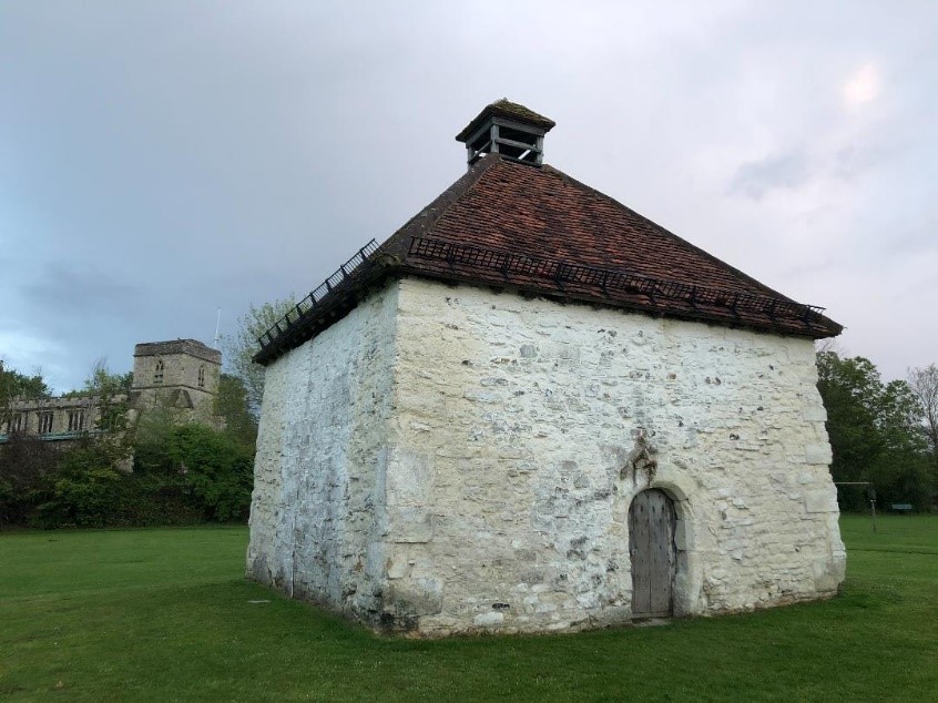
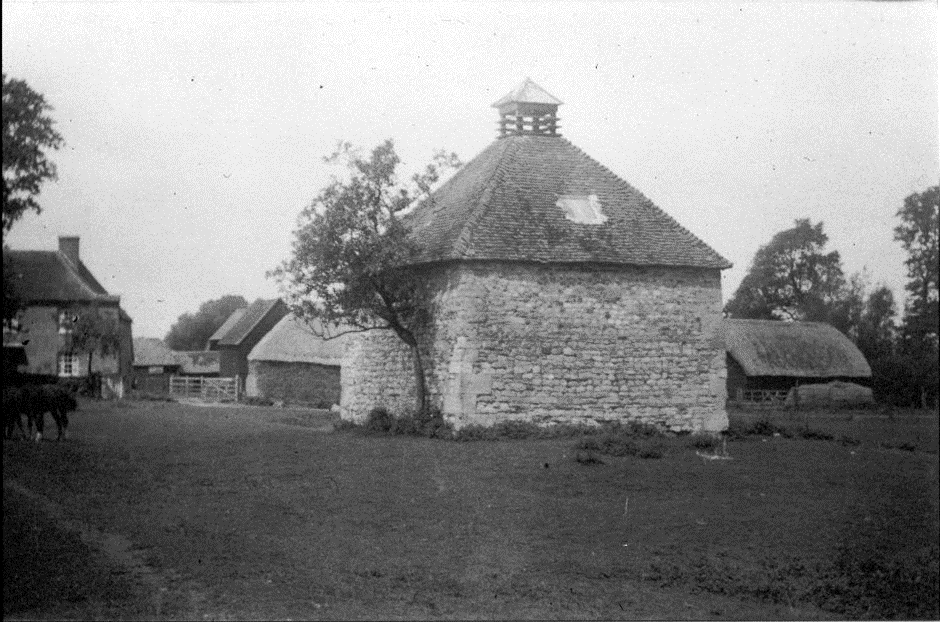
The square dovecote was built at some point during the 16th century. Dovecotes were used to house pigeons kept for food during the Summer and Autumn and the existence of such a structure denotes a religious or secular house of high status. (10) It is listed Grade II* and Historic England details its construction from “coursed rubble clunch with some flint and tile. Large dressed stone blocks at quoins. Pyramid tile roof, central timber entry turret with similar roof” (11)
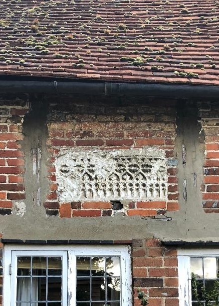
On the northwest elevation, there is a doorway under a chamfered semi-circular arch made from clunch which once had decorated carvings. It has been speculated that the door might have been a later addition or from an earlier structure on the site. Re-used carved stones can be seen in local houses such as this blind tracery panel in the English Gothic style dated to between 1290-1400 AD, also made from clunch, and set into the wall of a 17th century cottage in the village. (12) Perhaps they and the dovecote arch were architectural features from a lost older but rather smart building?
The site therefore continued as a working farm and, as well as the dovecote, there are records of a tannery on the north side and watercress beds to the south and east. (13)
There was strong opposition to Enclosure in Monks Risborough and it was not until 1830 that it was finally confirmed in an Act of Parliament. A counter petition from residents resulted in a unique clause was included in the Bill to appoint a Special Commissioner for the poor who were eventually allocated some fields to compensate for having lost their rights to gather woods once all of the woodlands in the parish were granted to the Earl of Buckinghamshire. (14) The 1831 Enclosure map shows the access lane to the west of the church, an agricultural field to its immediate north, a collection of buildings forming Place Farm including the alongside the watercress beds and further watercress beds in the section which now runs alongside Dunsmore Avenue.
By 1841, the Census reveals that Place Farm is run by Mr William Rogers but, by the 1851 Census, his 65 yr old widow, Rebecca Rogers is living at Place Farm with two agricultural labourers running the farm. In October 1853, an advertisement in the Bucks Herald newspaper (15) gives us some idea of the site itself; – “Desirable freehold, copyhold and leasehold for 700 years estates comprising the Place and Ham Farms, a Water Corn Mill, Cottage and Garden and Hatch Mead lands containing together about 114 (at MR only) acres whole estate producing a rental of £240 per annum” We also encounter the Pauling family living at the nearby Ham Farm who will take over running Place Farm by the end of the century.
By March 1897, Leonard Pauling, tenant of Place Farm had died but, at an auction in September 1899, Place Farm was sold by private treaty to the tenant, none other than Leonard’s widow, Isabella.
Isabella was still at Place Farm on the Census of 1901 with 6 of her children aged between 16 and 42 and the farm was clearly doing well, as, in October 1902, the Bucks Free Press announced the sale of farming stock including 200 sheep, 13 cattle, 12 horses, 7 ricks of hay, 6 corn ricks and 10 of wheat and oat straw at Place Farm. (16)

By 1911, Isabella’s son, Albert and his family are living at Place Farm although Isabella is elsewhere in Monks Risborough. Albert died in November 1916 although the sale of the farm did not take place until October 1920 when it was purchased by the Hitchcock family.
The 1939 National Register (17) reveals William. H. Hitchcock was a dairy farmer and he lived at Place Farm with his wife Jennie and their son, Bertram, a motor mechanic. Mr Hitchcock was interviewed around this time for an article on farming and Place Farm was described as “An ancient peace seems to linger there…, with the brown and white cattle grazing around…, the gold-roofed barns and gold of the haystacks catching the rays of the setting sun, the little streams running happily through the meadows and a distant rotund figure sitting quite still by the farmhouse door..,” (18)
In 1953, Mr Hitchcock was interviewed again by the Bucks Free Press about the possible compulsory purchase of the farm for housing development. He described it as ”70 acres which he had farmed for 33 years as good farming land with a stream running through and one of the best farms in the county…, I don’t think the time will come when my land will be needed for houses”.
Unfortunately for the farm, that time arrived and planning permission was granted in 1962. By 1964, the estate agents, Hamnett Rafferty were marketing “95% mortgages on detached, semi-detached houses and bungalows from £3,995 freehold at Place Farm” (19). It seems that some of the original farm buildings were retained for storage until the estate was finished. At some point during the mid-twentieth century, a large opening had been made on the east elevation of the dovecote, perhaps originally for cart storage, but this was later filled in with Purbeck limestone.
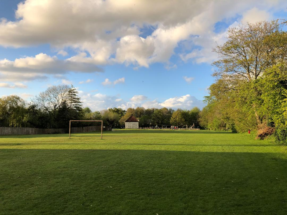
The 1970 Official Guide to Princes Risborough detailed how St Dunstan’s Park came into existence; – “This land which was recently acquired by the Parish Council has an acreage of 4.09 acres. The Parish council with the aid of grants from the county council has carried out extensive drainage and levelling works. It is intended to provide recreational facilities on the ground and the work will be phased over a number of years. The ground contains a Children’s Corner with slides etc..,”(20)
The creation of the park St Dunstan’s Park in the 1970s involved levelling the surface but there may be that further archaeological remains underneath. The playground equipment has been enhanced a number of times, the basketball court resurfaced and the football posts still provide for Saturday morning practice.
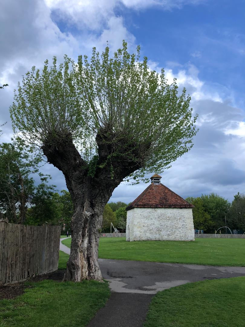
The Dovecote remains and, in 2015, a condition survey was carried out and the dovecote was returned to its historic appearance with limewash, the traditional approach to protecting the stonework.
A few old trees can be seen alongside or within the domestic gardens of the houses and the stream still separates the park from the church.
Jo Mirzoeff
References:
1.Eyers, Jill & Watkins, Hayley, “More Than Six-Feet-Under: The Big Dig at St Dunstan’s Churchyard” (Chiltern Archaeology, 2013) p.43
- The ecclesiastical parish included Meadle, Owlswick, Askett, Cadsden and Whiteleaf. The charter is held at the British Library
- https://opendomesday.org/place/SP8004/monks-risborough/
- Turner, G. J, “William the Conqueror’s March to London in 1066 “in The English Historical Review, Vol. 27, No. 106 (Apr., 1912), pp. 209-225 Published by Oxford University Press
- https://opendomesday.org/place/SP8004/monks-risborough/
- Or ‘Parva Risborwe’ (Little or Small Risborough) as it was also known
- Nichols, John F. “An Early Fourteenth Century Petition from the Tenants of Bocking to Their Manorial Lord “ in The Economic History Review, Vol. 2, No. 2 (Jan., 1930), page 300 Published by: Wiley on behalf of the Economic History Society
- 1534 Act of Supremacy when King Henry VIII separated from Rome and, in 1535, Henry sought to impose taxes on the church and ordered the “Valor Ecclesiasticus
- https://en.wikipedia.org/wiki/Monks_Risborough
- Huntingford, G ‘Dovecote, Monks Risborough, Buckinghamshire’ (De Montfort University, 1997/8)
- https://historicengland.org.uk/listing/the-list/list-entry/1125788
- Eyers & Watkins p.13
- Eyers & Watkins, p. 62
- Turner, Michael E.”The Cost of Parliamentary Enclosure in Buckinghamshire” taken from The Agricultural History Review, Vol. 21, No. 1 (1973), pp. 35-46 Published by: British Agricultural History Society
- Bucks Free Press, Saturday 8th October 1853 courtesy of the British Newspaper Archive
- Bucks Free Press, Saturday 11 October 1902 taken from the British Newspaper Archive
- The National Register was taken on 29th September 1939 at the onset of World War II to compile information for Identity Cards and then later to issue ration books
- Taken from an article ‘Farming Interviews No.6’ provided by the Princes Risborough Heritage Society, original source unknown
- Hammersmith & Shepherds Bush Gazette – Thursday 26 March 1964
- Princes Risborough Heritage Society
Photos @ Jo Mirzoeff unless otherwise credited.
With thanks to the Princes Risborough Heritage Society for their information and archive photos, to Councillor Alan Turner for further research, Geoff Huntingford for the loan of his assignment and to Norina Pauling for allowing me to use her family photos
